 Ireland · 14th century
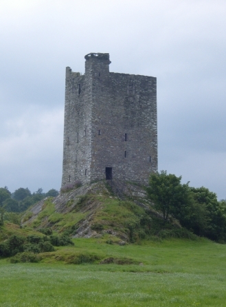
Carrigaphooca Castle ranks #5,694 of 9,040 worldwide in the atlas's castle fame ranking, and #95 of the 178 mapped in Ireland. Founded c. 1336, it is older than 58% of the atlas's dated landmarks, one of 758 atlas entries founded in the 14th century. 4 more atlas landmarks stand within 25 km. The nearest day-trip guide is Cork, 38 km away. See how Ireland compares in the castle statistics.
Carrigaphooca Castle (Irish: Caisleán Charraig a' Phúca meaning "castle on the rock of the fairy"; the word púca translates as ghost or fairy) is a ruined five storey rectangular tower house situated on a steep-sided rock overlooking the River Sullane. Carrigaphooca 6 km west of Macroom, County Cork, Ireland, in an area once known as Gleann na n-Dearg ("valley of the reds"). The tower dominates the landscape of Lissacresig (Fairyland) in Clondrohid, and Lower Shanballyshane, in Kilnamartyra. Carrigaphooca is made of sandstone and limestone and was built as a defensive tower by the MacCarthys of Muskerry in the early 15th century.
Carrigaphooca is positioned in an area rich with Neolithic monuments; Carrigaphooca Stone Circle lies two fields to the east, with a large standing stone (gallán) to the west. The tower is located on private property, and is no longer accessible to the public, although it is owned by the state and maintained by the Office of Public Works.
Text adapted from “Carrigaphooca Castle” on Wikipedia, CC BY-SA 4.0.
View on the interactive castle map →