Castle
Castell de Montpalau
🇪🇸 Spain
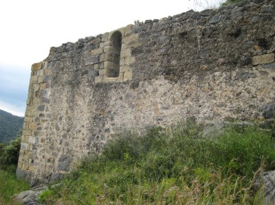
The Castell de Montpalau (in Catalan, Castell de Montpalau) is a fortified castle located at the summit of the Montpalau hill, at the south-western limit of the county of Girona, on the Pineda slopes of the Montnegre massif at an altitude of 269 metres.
The seigneurial jurisdiction covered a vast territory that included a large part of the Upper Maresme, from Arenys to Hortsavinyà as far as the limits of the domains of the castle of Palafolls.
This castle had the function of a fortress, and was not a permanent residence. Its role was rather to intimidate the local farmers and to provide occasional lodging for knights on their surveillance missions.
Machine-translated from “Château de Montpalau” on the French Wikipedia, CC BY-SA 4.0.
Castell de Montpalau ranks #7,273 of 8,134 worldwide in the atlas's castle fame ranking, and #461 of the 602 mapped in Spain. 6 more atlas landmarks stand within 25 km. The nearest day-trip guide is Girona, 40 km away. See how Spain compares in the castle statistics.
View on the interactive castle map →Frequently asked questions
Where is Castell de Montpalau?
Castell de Montpalau stands in Spain, at 41.64223°, 2.67035°.
How famous is Castell de Montpalau?
In this atlas's fame ranking: #7,273 of 8,134 worldwide, and #461 in Spain. Fame here combines how many Wikipedia language editions cover a landmark with how many people read them.
What is the nearest castle to Castell de Montpalau?
Castell de Palafolls, about 7 km away.
More castles in Spain
- Castle Granyena Spain · 16th century
- Castillo de la Mota (Urgull) Spain · 12th century
- Galartza dorrea Spain · 14th century
- Castle of Hostoles Spain
More castles
- Dalkey Castle Ireland · 14th century
- Castle of Asmesnal Spain
- Tistad Castle Sweden
- Castle of Moeche Spain · 15th century