Fortress
Dunbeg Fort
🇮🇪 Ireland
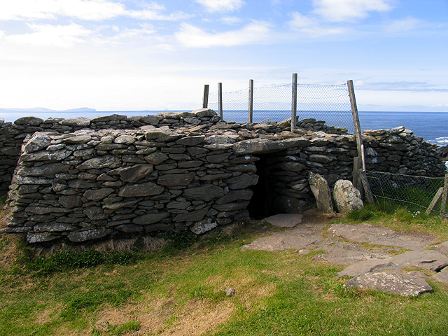
Dunbeg Fort (Irish: An Dún Beag) is a promontory fort built in the Iron Age near the modern village of Ventry in County Kerry, Ireland.
Dunbeg Fort is located on a rocky promontory just south of Slea Head on the Dingle Peninsula, looking over Dingle Bay to the south and the Atlantic Ocean to the west. The cliffs have eroded since it was built, and much of the fort has been lost to the sea.
The fort's wall cut off access to the triangular promontory, which was later occupied by a single large "beehive" hut.
Near to the fort there is a group of clocháns, small stone structures also known as beehive huts that seem to have been built around 1000 BC.
A visitor center at the site includes audiovisual displays, an information and craft room and a restaurant and café.
In January 2014 the fort was closed when much of the western wall of the fort fell into the sea due to storm damage. The Office of Public Works and National Monuments Service sent personnel to investigate damage to the site.
The fort was again closed in December 2017 and separately in January 2018 after further damage was inflicted by the season's storms.
Because of its exposed location, the location of Dunbeg Fort makes it vulnerable to natural weather events and the site's existence is threatened. The Office of Public Works has taken mitigating measures to reduce the impact of climate change on this site and protect its architectural, archaeological and natural features.
George Victor Du Noyer described the fort as it was when he visited in 1858.
The fort divided the point of a headland from the main shore with a dry stone wall between 15 and 25 feet (4.6 and 7.6 m) in width and about 200 feet (61 m) long from one side of the headland to the other.
A passage near the midpoint leads through the wall, which was then 3.5 feet (1.1 m) high, 2 feet (0.61 m) wide at the top and 3 feet (0.91 m) wide at the base. The lintel is 7 feet (2.1 m) long. The passage widens to 8 feet (2.4 m) inside the fort, with an arched ceiling.
In front of the defensive wall there are four parallel ditches separated by three clay and gravel mounds.
A pathway leads through this defence to the entrance of the fort.
It seems that originally the path ran through a stone passage with a flagged roof as it passed through each mound.
Text adapted from “Dunbeg Fort” on Wikipedia, CC BY-SA 4.0.
Dunbeg Fort ranks #4,321 of 8,134 worldwide in the atlas's castle fame ranking, and #70 of the 173 mapped in Ireland. 3 more atlas landmarks stand within 25 km. See how Ireland compares in the castle statistics.
View on the interactive castle map →Frequently asked questions
Where is Dunbeg Fort?
Dunbeg Fort stands in Ireland, at 52.10333°, -10.40861°.
How famous is Dunbeg Fort?
In this atlas's fame ranking: #4,321 of 8,134 worldwide, and #70 in Ireland. Fame here combines how many Wikipedia language editions cover a landmark with how many people read them.
What is the nearest castle to Dunbeg Fort?
Rahinnane Castle, about 5 km away.
More castles in Ireland
- Parke's Castle Ireland · 17th century
- Staigue Fort Ireland · 1st century BC
- Cullahill Castle Ireland · 15th century
- Huntington Castle Ireland · 17th century
More fortresses
- Fort Pitt United States · 18th century
- Fort Oswego United States · 18th century
- Fort York Canada · 18th century
- Fort Mose United States · 18th century