Fortress
Fort Stevens
🇺🇸 United States · 19th century
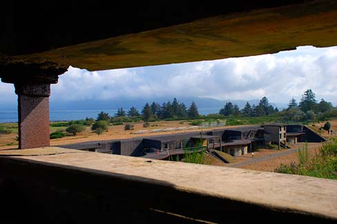
Fort Stevens was an American military installation that guarded the mouth of the Columbia River in the state of Oregon. Built near the end of the American Civil War, it was named for Civil War general and former Washington Territory governor Isaac I. Stevens. The fort was an active military reservation from 1863–1947. It is now listed on the National Register of Historic Places.
Today the site is an Oregon state park just northwest of Warrenton.
Text adapted from “Fort Stevens (Oregon)” on Wikipedia, CC BY-SA 4.0.
Fort Stevens ranks #2,810 of 8,134 worldwide in the atlas's castle fame ranking, and #55 of the 103 mapped in United States. Founded 1863, it is older than 7% of the atlas's dated landmarks — one of 607 atlas entries founded in the 19th century. Its Wikipedia articles were opened 3,946 times in the last 60 days, more than 81% of the atlas. 1 more atlas landmarks stand within 25 km. See how United States compares in the castle statistics.
View on the interactive castle map →Frequently asked questions
Where is Fort Stevens?
Fort Stevens stands in the United States, at 46.2019°, -123.963°.
When was Fort Stevens built?
The atlas dates its founding to 1863. Earlier structures may have stood on the site; this is the earliest documented founding year.
How famous is Fort Stevens?
In this atlas's fame ranking: #2,810 of 8,134 worldwide, and #55 in the United States. Fame here combines how many Wikipedia language editions cover a landmark with how many people read them.
What is the nearest castle to Fort Stevens?
Fort Clatsop, about 10 km away.
More castles in the United States
- Fort Washington United States
- Fort Le Boeuf United States · 18th century
- Fort Laramie United States · 19th century
- Fort Robinson United States
More fortresses
- Cahercommaun Ireland · 9th century
- Fort de Barchon Belgium · 19th century
- Fort d'Embourg Belgium · 19th century
- Fort Regent Jersey · 19th century