Ruin
Huis ter Kleef
🇳🇱 Netherlands · 14th century
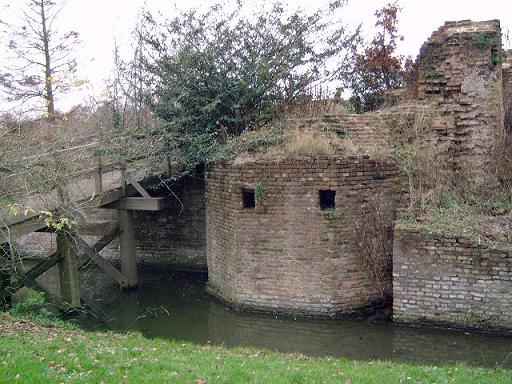
The ruins of the Huis ter Kleef castle are located in the city gardens of Haarlem.
The castle is located about halfway between the Brederode Castle and the Haarlem City Hall, which were built respectively in the second half of the 13th century and 1370, and probably dates from that period, when it is referred to as Huis te Schoten. Situated a mile and a half from Haarlem center, in those days it was situated in the middle of a town called Schoten. In 1403 it was given to Margaret of Cleves (c.1375-1411), and has since retained that name.
During the Siege of Haarlem in 1572 it was the headquarters of the Spanish army, under the leadership of the duke of Alva. It was blown up in 1573 and badly damaged, the rubble was used for city expansion. The house nearby with a tower called the "Kaatsbaan" was long considered the only building left standing, though recent archeological research suggests that the foundations have older stones than the rest and perhaps it was itself rebuilt after the explosion. The property changed hands several times until it was purchased by the city of Haarlem in 1713. The name "Kaatsbaan" refers to the sport Jeu de paume, an indoor precursor of tennis or to "Kaatsen" (Frisian handball), which presumably was once played here, though in the 18th century thiswhat? was probably "Kolven", a sport somewhat like golf. The St. Eloy's Hospice, an old guild hall in the center of Utrecht, similarly became a center for the Kolf sport after the guilds were disbanded.
Stones from the central castle ruin can still be seen in surrounding buildings. The Kaatsbaan was used as a residence for former owners and is now also in use by the city gardens.
In February 2006, the City of Haarlem agreed to a proposal to restore the court at Huis ter Kleef, if the Real Tennis Club Huis ter Kleef could raise the necessary funds (approximately €1,450,000).
Text adapted from “Huis ter Kleef” on Wikipedia, CC BY-SA 4.0.
Huis ter Kleef ranks #6,654 of 8,134 worldwide in the atlas's castle fame ranking, and #113 of the 201 mapped in Netherlands. Founded 1370, it is older than 56% of the atlas's dated landmarks — one of 604 atlas entries founded in the 14th century. 15 more atlas landmarks stand within 25 km. The nearest day-trip guide is Amsterdam, 17 km away. See how Netherlands compares in the castle statistics.
View on the interactive castle map →Frequently asked questions
Where is Huis ter Kleef?
Huis ter Kleef stands in the Netherlands, at 52.3959°, 4.63464°.
When was Huis ter Kleef built?
The atlas dates its founding to 1370. Earlier structures may have stood on the site; this is the earliest documented founding year.
How famous is Huis ter Kleef?
In this atlas's fame ranking: #6,654 of 8,134 worldwide, and #113 in the Netherlands. Fame here combines how many Wikipedia language editions cover a landmark with how many people read them.
What is the nearest castle to Huis ter Kleef?
Castle Brederode, about 3 km away.
More castles in the Netherlands
- Castle Egmond Netherlands · 12th century
- Motte Montferland Netherlands
- Landsfort Herle Netherlands · 13th century
- Polanen Castle Netherlands · 13th century
More ruins
- Fort Amsterdam (Sint Eustatius) Netherlands · 18th century
- Rize Castle Turkey · 6th century
- Softa Castle Turkey
- Tece Castle Turkey