Ruïne
Pungnaptoseong
🇰🇷 Zuid-Korea
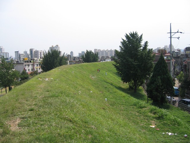
Pungnaptoseong (Koreaans: 풍납토성; Hanja: 風納土城) is een vlakke aarden wal aan de oever van de Han-rivier in het huidige Pungnap-dong, Songpa-gu, Seoel, Zuid-Korea. Ze heeft een omtrek van 3,5 km. Vroeger maakte ze deel uit van de naburige stad Gwangju. Ze heeft een langwerpige ovale vorm, die zich uitstrekt naar noord en zuid, en licht naar het oosten helt. Op basis van onderzoek tijdens de Japanse bezetting wordt vermoed dat Pungnap Toseong Hanam Wiryeseong was, de eerste hoofdstad van Baekje.
Slechts 2,7 km van de muren is bewaard gebleven. Inclusief de westelijke muur, die door overstroming was verwoest, bedraagt de omtrek circa 3,5 km en het oppervlak bijna 859.508 m². Na de bouw van dit centrale deel werd de binnenmuur, voornamelijk opgebouwd uit zanderige grond, grind, kleiachtige grond en modderige grond, schuin opgeworpen met aarde. Bovenop de laatste aarden laag van de binnenmuur werden kiezelstenen in drie lagen gelegd en werden bewerkte stenen tot 1,5 m hoog opgestapeld met modder gemaakt van natuurlijke grond, waarbij het centrale deel werd opgeworpen in trapeziumvorm met een onderkant van 7 m breed en 5 m hoog.
Machinaal vertaald uit “P'ungnapt'osŏng” op de Engelstalige Wikipedia, CC BY-SA 4.0.
Pungnaptoseong staat op plaats 5.757 van 8.134 in de bekendheidsranglijst van deze atlas en op plaats 18 van de 58 die de atlas in Zuid-Korea in kaart brengt. Binnen 25 km staan nog 13 andere bouwwerken uit de atlas. De dichtstbijzijnde dagtripgids is Seoel, 12 km verderop. Zie hoe dat zich verhoudt in de kastelenstatistiek.
Bekijk op de interactieve kastelenkaart →Veelgestelde vragen
Waar ligt Pungnaptoseong?
Pungnaptoseong ligt in Zuid-Korea, op 37.53027°, 127.1162°.
Hoe bekend is Pungnaptoseong?
In de bekendheidsranglijst van deze atlas: plaats 5.757 van 8.134 wereldwijd, plaats 18 in Zuid-Korea. Bekendheid combineert het aantal Wikipedia-taalversies met het aantal lezers.
Welk kasteel ligt het dichtst bij Pungnaptoseong?
Mongchontoseong, ongeveer 1 km verderop.
Meer kastelen in Zuid-Korea
- Samnyeonsanseong Zuid-Korea · 5e eeuw
- Namhae Japanese Castle Zuid-Korea
- Doksanseong Zuid-Korea
- Dongnaeeupseong Fortress Zuid-Korea · 11e eeuw
Meer ruïnes
- Cizre Castle Turkije
- Fort Komenda Ghana · 17e eeuw
- Shanqal Fort Saoedi-Arabië
- Hama Castle Syrië