Ruin
Fort Witsen
🇬🇭 Ghana · 17th century
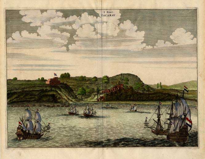
Fort Witsen, also Fort Tacaray, was a fort on the Dutch Gold Coast, established in 1665 near Takoradi. This fort was destroyed after a few years, and in 1684 the site was abandoned. A map from 1791 shows, however, that the Dutch had renewed their presence in the fort again. The fort was handed over to Britain, along with the entire Dutch Gold Coast, on 6 April 1872, owing to the provisions of the Anglo-Dutch Treaties of 1870-1871.
Text adapted from “Fort Witsen” on Wikipedia, CC BY-SA 4.0.
Fort Witsen ranks #6,648 of 8,134 worldwide in the atlas's castle fame ranking, and #27 of the 34 mapped in Ghana. Founded 1665, it is older than 25% of the atlas's dated landmarks — one of 626 atlas entries founded in the 17th century. 4 more atlas landmarks stand within 25 km. The nearest day-trip guide is Sekondi-Takoradi, 2 km away. See how Ghana compares in the castle statistics.
View on the interactive castle map →Frequently asked questions
Where is Fort Witsen?
Fort Witsen stands in Ghana, at 4.91669°, -1.74992°.
When was Fort Witsen built?
The atlas dates its founding to 1665. Earlier structures may have stood on the site; this is the earliest documented founding year.
How famous is Fort Witsen?
In this atlas's fame ranking: #6,648 of 8,134 worldwide, and #27 in Ghana. Fame here combines how many Wikipedia language editions cover a landmark with how many people read them.
What is the nearest castle to Fort Witsen?
Fort Orange (Ghana), about 5 km away.
More castles in Ghana
- Fort Komenda Ghana · 17th century
- Fort Victoria Ghana · 19th century
- Fort Elize Carthago Ghana · 18th century
- Fort De Veer Ghana
More ruins
- Castle of Alcantarilha Portugal
- Brody Castle Ukraine · 17th century
- Międzyrzecz Castle Poland · 14th century
- Świecie Castle (Kuyavia) Poland · 14th century