 Netherlands · 14th century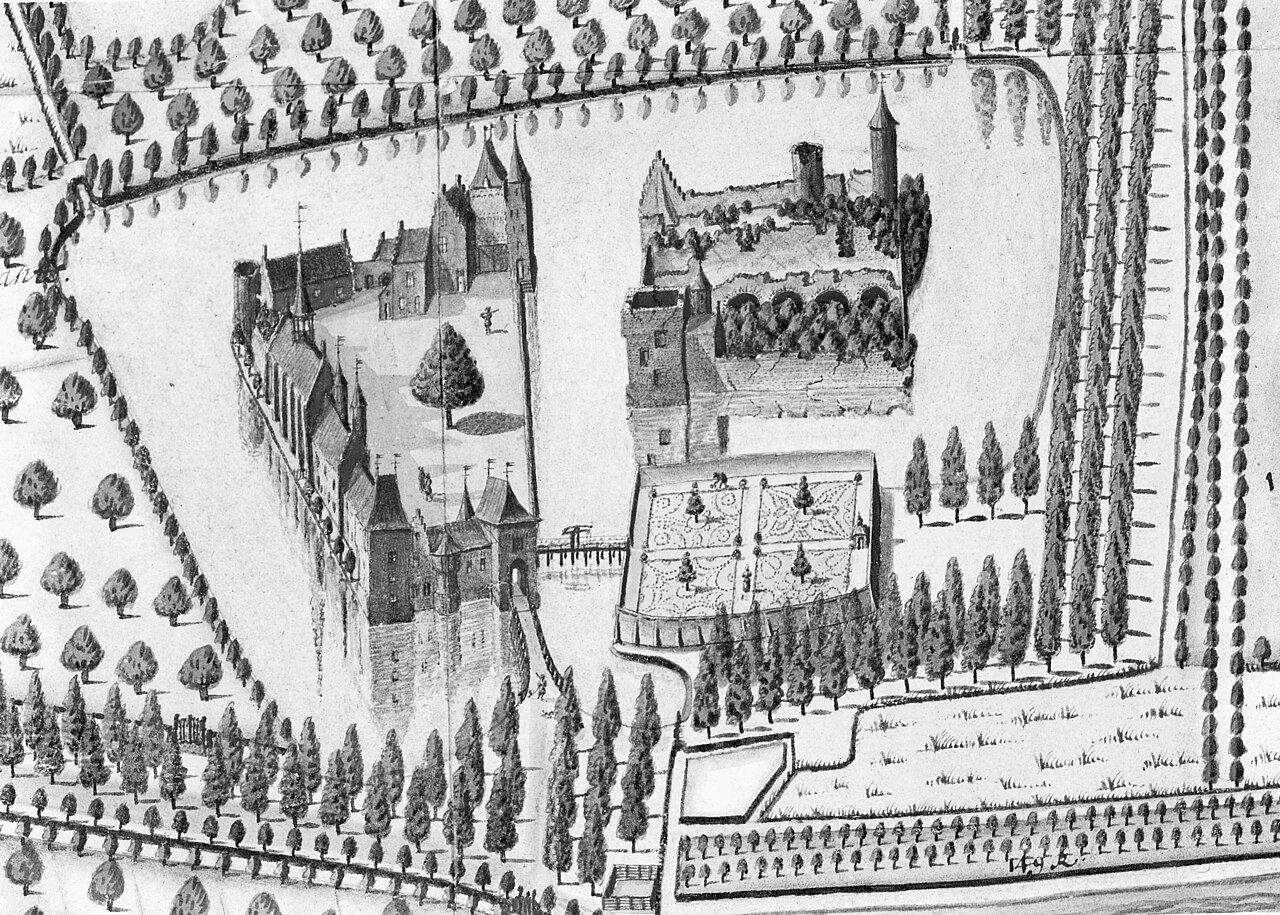
Sint-Maartensdijk Castle was a castle with a rich history. Except for a part of the moats nothing remains of it.
The village Sint-Maartensdijk is located in the Oudelandpolder on the island Tholen. This is the oldest polder west of the Pluimpot, which is the old trench that used to split Tholen in two. The old map of Tholen shows Sint-Maartensdijk, the Oudelandpolder and the Pluimpot just southwest of its center. The Pluimpot used to be named Borden. Therefore, the oldest name of the area around Sint-Maartensdijk was Overbordene, meaning 'Over the Borden'.
The village of Sint-Maartensdijk was previously named Haestinge. Some say this referred to a hare haas which is also on the old coat of arms of the village. Others say that Haestinge comes from 'Haast-Ee', another old name for the Pluimpot. Anyway, the inhabitants of Haestinge were mentioned as such in 1357. After 1357 a new church was founded dedicated to Martin of Tours, and the village was renamed accordingly. In 1485 the village became a small city, and was fortified.
Sint-Maartensdijk Castle is thus named after the village which became a town. It stood about a hundred meters north of the city walls. At present, the terrain is on the limits of the village, and borders a cemetery and a parking lot which was constructed over part of its western outer bailey.
In its first phase Sint-Maartensdijk Castle consisted of a solitary tower house with a water well inside. The walls of this tower house were 2.5 m thick on average. This tower might have been built on the same location as the 13th century residence of its first known owners, the Van Overbordene family. However, these might just as well have had their castle on one of the nearby mottes. Some late thirteenth century mottes were located near Sint-Maartensdijk, and indeed contained medieval brick.
During the second phase, the Van Bordenes expanded the tower house to a water castle. It was an irregular square with four or five semi-circular towers, and two smaller towers, all at irregular intervals.
This was also the phase during which the outer-bailey got a wall with a protected walkway on brick arcs. It is not clear whether the two big gatehouses of the outer bailey belong to this second phase or the next, third phase.
A third phase took place during the 15th century. West of the castle a stud farm was built.
Text adapted from “Sint-Maartensdijk Castle” on Wikipedia, CC BY-SA 4.0.
Kasteel van Sint-Maartensdijk ranks #7,822 of 9,035 worldwide in the atlas's castle fame ranking, and #141 of the 198 mapped in Netherlands. Founded c. 1310, it is older than 60% of the atlas's dated landmarks, one of 757 atlas entries founded in the 14th century. 2 more atlas landmarks stand within 25 km. The nearest day-trip guide is Bergen op Zoom, 16 km away. See how Netherlands compares in the castle statistics.
View on the interactive castle map →