Fortress
Yongtai Fortress
🇨🇳 China · 17th century
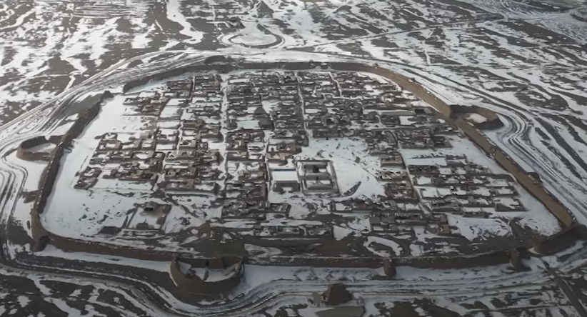
Yongtai Fortress is a village and historical fortress town in Sitan Township, Jingtai County, Baiyin City, Gansu, China. Built in 1608 by the Ming dynasty rulers to defend against attacks from northern minorities, it stationed 2000 infantrymen and 500 cavalry units. The entire fort is enclosed by a rammed earth wall including defensive towers. Due to desertification, the village is now mostly abandoned, dropping from 1500 people in the 1950s, to around 100 today.
Text adapted from “Yongtai Fortress” on Wikipedia, CC BY-SA 4.0.
Yongtai Fortress ranks #5,012 of 8,134 worldwide in the atlas's castle fame ranking, and #64 of the 119 mapped in China. Founded 1608, it is older than 32% of the atlas's dated landmarks — one of 626 atlas entries founded in the 17th century. Its Wikipedia articles were opened 1,228 times in the last 60 days, more than 54% of the atlas. See how China compares in the castle statistics.
View on the interactive castle map →Frequently asked questions
Where is Yongtai Fortress?
Yongtai Fortress stands in China, at 37.1359°, 103.8463°.
When was Yongtai Fortress built?
The atlas dates its founding to 1608. Earlier structures may have stood on the site; this is the earliest documented founding year.
How famous is Yongtai Fortress?
In this atlas's fame ranking: #5,012 of 8,134 worldwide, and #64 in China. Fame here combines how many Wikipedia language editions cover a landmark with how many people read them.
More castles in China
- Fortaleza de Mong Há China · 19th century
- Murray Battery China · 19th century
- Yuejiang Lou China
- Miaojiang Great Wall China · 16th century
More fortresses
- Trelleborg ring fort Sweden
- Mola Fortress Spain · 19th century
- Fort de Bèrnia Spain · 16th century
- Marinid Walls of Algeciras Spain