Twierdza
Twierdza Santa Teresa
Fortaleza de Santa Teresa · 🇺🇾 Urugwaj · XVIII wiek
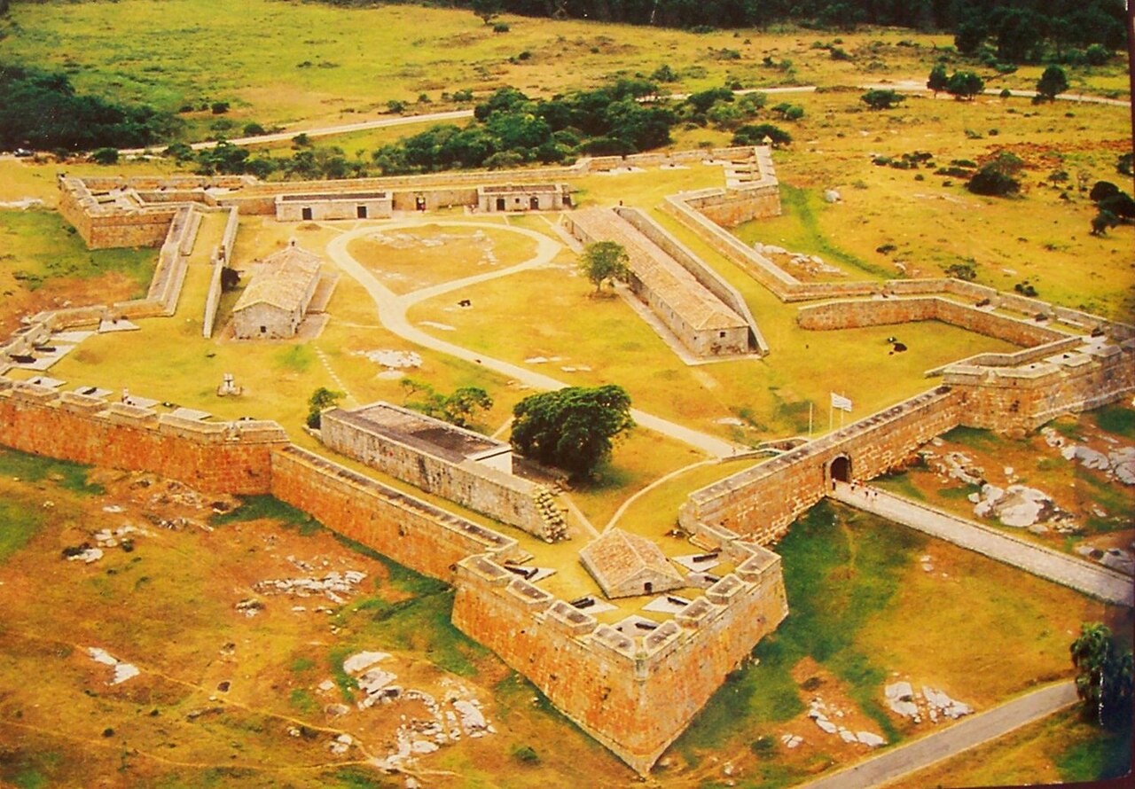
Fortaleza de Santa Teresa, znana też jako Fortaleza Santa Tereza, to fortyfikacja wojskowa położona 36 km (22 mile) na południe od Chuy i 305 km (190 mil) na północny wschód od Montevideo, przy drodze Route 9, w departamencie Rocha we wschodnim Urugwaju. Leży około 800 m (2600 stóp) od wybrzeża przy Playa la Moza, mniej więcej w połowie drogi między Angosturą (na południu) a La Coronillą (na północy), na północ od Punta del Diablo i mniej więcej 4 km (2,5 mili) na północny wschód od północno-wschodniego brzegu laguny Laguna Negra. Znajduje się na terenie parku narodowego Santa Teresa. Fortyfikację wzniesiono od października 1762 roku przez Portugalczyków, którzy porzucili wcześniejszą próbę budowy fortu w Maldonado i opuścili Fuerte San Miguel.
Tłumaczenie maszynowe artykułu „Fortaleza de Santa Teresa” w angielskiej Wikipedii, CC BY-SA 4.0.
Twierdza Santa Teresa zajmuje 4038. miejsce na 8134 w rankingu rozpoznawalności zamków tego atlasu i 2. wśród 2 obiektów w Urugwaju. Data powstania — 1762, wcześniejsza niż u 16% datowanych obiektów atlasu — jeden z 556 obiektów atlasu powstałych w XVIII wieku. Artykuły o tym obiekcie w Wikipedii otwarto 1149 razy w ciągu ostatnich 60 dni — więcej niż 52% obiektów atlasu. Zobacz w statystykach zamków, jak wypada Urugwaj.
Zobacz na interaktywnej mapie zamków →Najczęstsze pytania
Gdzie znajduje się Twierdza Santa Teresa?
Twierdza Santa Teresa znajduje się w Urugwaju, na współrzędnych -33.97222°, -53.54861°.
Z którego roku pochodzi Twierdza Santa Teresa?
Atlas podaje rok powstania: 1762. Wcześniejsze budowle mogły stać w tym miejscu — to najstarszy udokumentowany rok.
Które miejsce w rankingu zajmuje Twierdza Santa Teresa?
W rankingu rozpoznawalności tego atlasu: 4038. miejsce na 8134, 2. miejsce w Urugwaju. Rozpoznawalność łączy liczbę wersji językowych Wikipedii z liczbą czytelników.
Twierdza Santa Teresa — który zamek leży najbliżej?
Fortaleza del Cerro, około 269 km stąd.
Inne obiekty: twierdze
- Verkhoturye Kremlin Rosja · XVII wiek
- Fortress of Muxima Angola · XVI wiek
- Borj Nord Maroko · XVI wiek
- Fort Stevens Stany Zjednoczone · XIX wiek