Fortress
Ertij Fort
🇦🇲 Armenia · 13th century
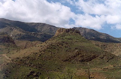
Ertij is a fort built during the 13th century. It is situated upon a hill adjacent to the village of Arpi in the Vayots Dzor Province of Armenia. Nearby in the gorge carved by the Arpa River is the cave shrine of Jrovank.
Text adapted from “Ertij Fort” on Wikipedia, CC BY-SA 4.0.
Ertij Fort ranks #5,635 of 8,134 worldwide in the atlas's castle fame ranking, and #21 of the 28 mapped in Armenia. Founded c. 1250, it is older than 69% of the atlas's dated landmarks — one of 861 atlas entries founded in the 13th century. 2 more atlas landmarks stand within 25 km. The nearest day-trip guide is Yerevan, 81 km away. See how Armenia compares in the castle statistics.
View on the interactive castle map →Frequently asked questions
Where is Ertij Fort?
Ertij Fort stands in Armenia, at 39.7393°, 45.2705°.
When was Ertij Fort built?
The atlas dates its founding to c. 1250. Earlier structures may have stood on the site; this is the earliest documented founding year.
How famous is Ertij Fort?
In this atlas's fame ranking: #5,635 of 8,134 worldwide, and #21 in Armenia. Fame here combines how many Wikipedia language editions cover a landmark with how many people read them.
What is the nearest castle to Ertij Fort?
Proshaberd, about 10 km away.
More castles in Armenia
- Aghchka berd Armenia · 13th century
- Ushiberd Armenia
- Akhtala Fotress Armenia
- Berdkunk Fortress Armenia · 10th century
More fortresses
- Fort Loudoun United States · 18th century
- Fort Negley United States
- Fort of Monserrate Brazil · 16th century
- Waterfort Curaçao · 19th century