Ruin
Burg Kirkel
🇩🇪 Germany · 12th century
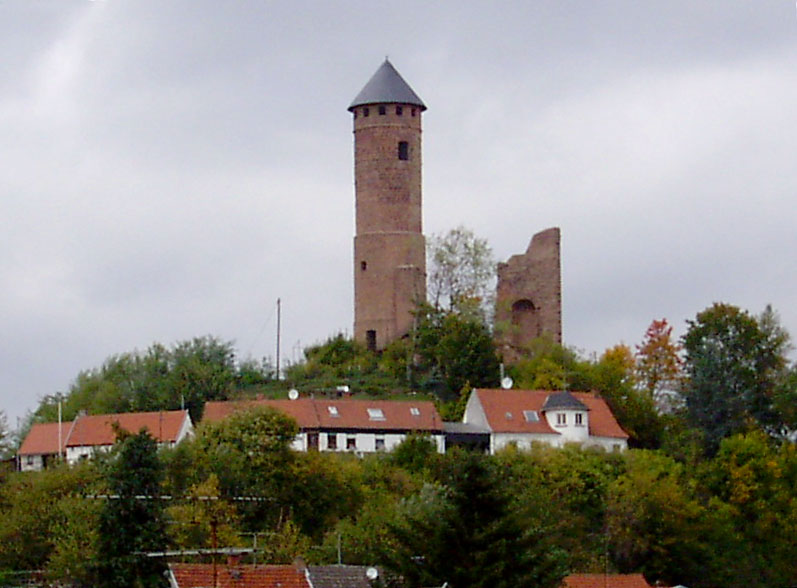
Burg Kirkel (Kirkel Castle), also known as the Kirkeler Burg, is a hill castle ruin located on a sandstone spur above Kirkel-Neuhäusel in the Saarpfalz district of Saarland, Germany. It is a prominent regional landmark and a cultural-historical focal point for the municipality of Kirkel.
Burg Kirkel stands atop a detached Buntsandstein (colored sandstone) hill known as the Schlossberg, rising to approximately 307 m above sea level. Its elevated position allowed the castle's occupants to command a wide view over the surrounding landscape, making it naturally defensible on most sides.
The castle was strategically selected to monitor and control a medieval trade and travel route known as the Geleitstraße ("escort road"), which later became part of the Kaiserstraße. This position allowed Burg Kirkel to protect merchants traveling between Metz and the Upper Rhine, as well as the surrounding villages, and to enforce tolls or escort rights (*Geleitrecht*) along the route.
Archaeological evidence, including foundation walls, Zwinger structures, and a northern well tower (*Brunnenturm*), confirms the castle's defensive capabilities, ensuring water access and resilience during sieges. Its commanding height and fortifications made it a military stronghold, as evidenced by remains of a drawbridge, curtain walls and the proximity to the Via Regia, an administrative center, consolidating local political and economic influence over the region as they controlled part of the route.
The first documented mention of the castle dates to 1075, in connection with a Count Gottfried of Kirkel.
During the early 12th century, Burg Kirkel passed into the hands of the Counts of Saarwerden.
Between 1214 and 1386, the Herren von Kirkel (Lords of Kirkel) held the castle as an imperial fief (Reichslehen), achieving imperial immediacy.
After the extinction of the Kirkel line in 1386, the castle eventually passed to the Dukes of Palatinate–Zweibrücken.
Between 1580 and 1596, Duke John I, Count Palatine of Zweibrücken converted parts of the medieval fortress into a residential palace in the Renaissance style Thirty Years' War (1618–1648) caused repeated damage, leading to partial abandonment.
In 1677, during the Franco-Dutch War, the castle was severely damaged by fire.
Text adapted from “Burg Kirkel” on Wikipedia, CC BY-SA 4.0.
Burg Kirkel ranks #6,102 of 8,134 worldwide in the atlas's castle fame ranking, and #466 of the 505 mapped in Germany. Founded c. 1200, it is older than 77% of the atlas's dated landmarks — one of 564 atlas entries founded in the 12th century. 2 more atlas landmarks stand within 25 km. The nearest day-trip guide is Saarbrücken, 18 km away. See how Germany compares in the castle statistics.
View on the interactive castle map →Frequently asked questions
Where is Burg Kirkel?
Burg Kirkel stands in Germany, at 49.2831°, 7.24028°.
When was Burg Kirkel built?
The atlas dates its founding to c. 1200. Earlier structures may have stood on the site; this is the earliest documented founding year.
How famous is Burg Kirkel?
In this atlas's fame ranking: #6,102 of 8,134 worldwide, and #466 in Germany. Fame here combines how many Wikipedia language editions cover a landmark with how many people read them.
What is the nearest castle to Burg Kirkel?
Zweibrücken Castle, about 10 km away.
More castles in Germany
- Burg Henneberg Germany · 11th century
- Klusenstein Castle Germany · 14th century
- Burg Baldenau Germany
- Castle of Ludwigstein Germany · 15th century
More ruins
- Tannenfels Castle Germany · 13th century
- Thann Castle Germany · 12th century
- Hohenneuffen Castle Germany · 12th century
- Breitenstein Castle Germany · 13th century