 Scotland · 1st century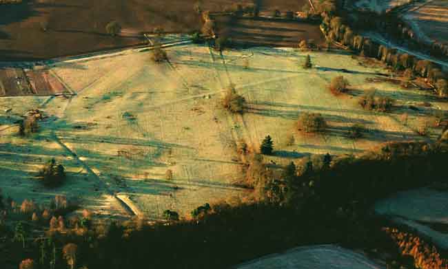
Inchtuthil is the site of a Roman legionary fortress situated on a natural platform overlooking the north bank of the River Tay southwest of Blairgowrie, Perth and Kinross, Scotland (Roman Caledonia).
It was built in AD 82 or 83 as the advance headquarters for the forces of governor Gnaeus Julius Agricola in his campaign against the Caledonian tribes. Positioned at the head of one of the main routes in and out of the Scottish Highlands, it was occupied by Legion XX Valeria Victrix and covered a total area of 21.5 hectares (53 acres).
Construction of the large fortress would have taken two or three seasons and a temporary camp was built nearby to house and protect the soldiers over the winter. Additional, smaller forts were built further north and south at the mouth of each nearby glen forming what are now referred to as the Glenblocker forts.
The fort at Inchtuthil is thought to be part of the Glenblocker forts, as well as others in Strathmore, such as Cardean and Stracathro, formed a uniform system composed of several elements, the forts and watchtowers on the Roman road of the Gask Ridge, the Glenblockers and the Strathmore forts. Inchtuthil as the largest military base would have functioned as the lynch-pin and the only site large enough to launch an invasion into the Highlands and beyond.
Text adapted from “Inchtuthil” on Wikipedia, CC BY-SA 4.0.
Castra Pinnata ranks #1,824 of 9,079 worldwide in the atlas's castle fame ranking, and #65 of the 226 mapped in Scotland. Founded 82, it is older than 98% of the atlas's dated landmarks — one of 33 atlas entries founded in the 1st century. Its Wikipedia articles were opened 2,275 times in the last 60 days, more than 72% of the atlas. 6 more atlas landmarks stand within 25 km. The nearest day-trip guide is Dundee, 29 km away. It is one of the 76 landmarks on the atlas's regional map of the Scottish Highlands. See how Scotland compares in the castle statistics.
View on the interactive castle map →