Fortress
HM Fort Roughs
ENG England · 20th century
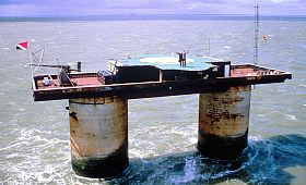
HM Fort Roughs is one of several World War II installations that were designed by Guy Maunsell and known collectively as His Majesty's Forts or as Maunsell Sea Forts; the purpose of which was to guard the port of Harwich, Essex, and more broadly, the Thames estuary. This 4,500 ton artificial naval installation is similar in some respects to "fixed" offshore oil platforms. It is situated on Rough Sands, a sandbar located approximately 11 kilometres (6 nmi) from the coast of Suffolk and 13 kilometres (7 nmi) from the coast of Essex. Today it is the location and de-facto capital of the unrecognised, self-proclaimed state of Sealand.
Text adapted from “HM Fort Roughs” on Wikipedia, CC BY-SA 4.0.
HM Fort Roughs ranks #1,879 of 8,134 worldwide in the atlas's castle fame ranking, and #121 of the 333 mapped in England. Founded 1942 — one of 169 atlas entries founded in the 20th century. Its Wikipedia articles were opened 17,551 times in the last 60 days, more than 96% of the atlas. 1 more atlas landmarks stand within 25 km. The nearest day-trip guide is Colchester, 40 km away. See how England compares in the castle statistics.
View on the interactive castle map →Frequently asked questions
Where is HM Fort Roughs?
HM Fort Roughs stands in England, at 51.89517°, 1.4805°.
When was HM Fort Roughs built?
The atlas dates its founding to 1942. Earlier structures may have stood on the site; this is the earliest documented founding year.
How famous is HM Fort Roughs?
In this atlas's fame ranking: #1,879 of 8,134 worldwide, and #121 in England. Fame here combines how many Wikipedia language editions cover a landmark with how many people read them.
What is the nearest castle to HM Fort Roughs?
Orford Castle, about 22 km away.
More castles in England
- Banna England · 2nd century
- Castrum Anderitum England · 3rd century
- Magna Roman Fort England
- Danebury Hill Camp England · 6th century BC
More fortresses
- Puerta de la Macarena (Seville) Spain · 12th century
- Tower of Mendoza Spain · 13th century
- Castell Henllys Wales
- Tap o' Noth Scotland