 Canada · 18th century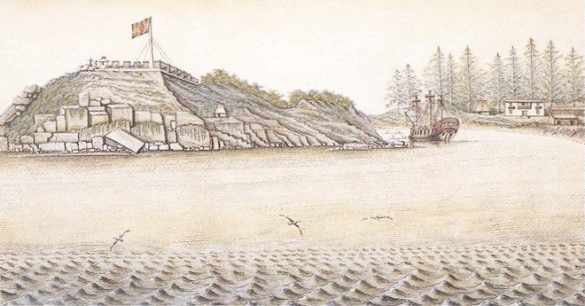
Fort San Miguel was a Spanish fortification at Yuquot (formerly Friendly Cove) on Nootka Island, just west of north-central Vancouver Island. It protected the Spanish settlement, called Santa Cruz de Nuca, the first colony in British Columbia.
It was first built by Esteban José Martínez in 1789 but dismantled in October of that year. It was then rebuilt and enlarged in 1790 then Nootka Sound was reoccupied by Francisco de Eliza. The fort was essentially an artillery land battery for the defence of the harbour and buildings. The Spanish settlement, called Santa Cruz de Nuca, was the first colony in British Columbia.
The fort lay near the home of Maquinna, chief of the Mowachaht group, who are now in the joint Mowachaht/Muchalaht First Nations band government with the Muchalaht at Gold River nearby on Vancouver Island.
On May 15, 1789, Martínez chose the location of his fortification at the entrance of Friendly Cove on Hog Island. Work progressed so that on May 26 they were able to place their artillery followed by the construction of barracks and a powder storeroom. On June 24, 1789, a salvo was fired from the new fort and the Spanish ships in what Martínez considered an official act of possession of Nootka Harbour. On July 4, the American vessels and their captains Gray and Kendrick (who had arrived in the harbour 7 months earlier than Martínez) fired salvos and fireworks in recognition of their recent independence from Britain accompanied by a further salvo from the Spanish fort.
On July 29, 1789, new orders arrived from Viceroy Flores directing Martínez to abandon the station and return to San Blas. The artillery from the fort was loaded back aboard the Princesa and he left Friendly Cove on October 30, 1789. The fort was dismantled, but anticipating a reoccupation, Martínez buried crates of bricks and lime.
The fort was rebuilt one year later, in 1790, by Pedro de Alberni, a senior captain of the Spanish Army, who served the Spanish Crown in the First Free Company of Volunteers of Catalonia along with 80 other men. They sailed to Nootka with the Francisco de Eliza expedition. After arriving at Nootka, Eliza established three lines of defence: the 300-ton frigate Concepción, the soldiers under Alberni on land and on the frigate, and the rebuilding of the battery on San Miguel Island. The construction of the battery was difficult.
Text adapted from “Fort San Miguel” on Wikipedia, CC BY-SA 4.0.
Fort San Miguel ranks #2,769 of 9,035 worldwide in the atlas's castle fame ranking, and #15 of the 26 mapped in Canada. Founded 1789, it is older than 13% of the atlas's dated landmarks, one of 685 atlas entries founded in the 18th century. Its Wikipedia articles were opened 1,713 times in the last 60 days, more than 65% of the atlas. See how Canada compares in the castle statistics.
View on the interactive castle map →