 Ukraine · 12th century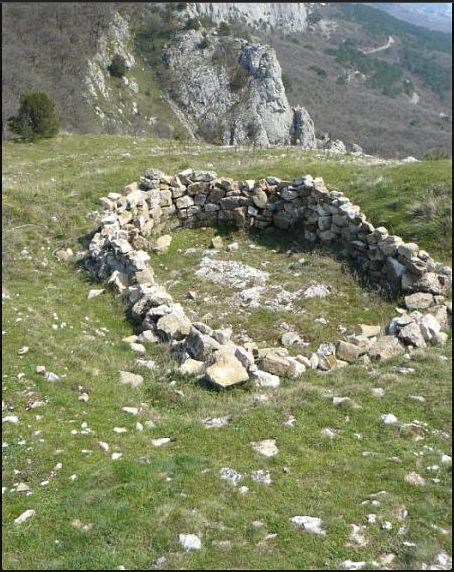
Merdven-Isar (also Isar-Kaya) is the ruins of a small medieval fortress of the 12th–13th century on the summit of the same name by the cliff of the Ai-Petri Yaila, approximately 250 m north of the upper exit of Shaitan-Merdven.
The small fortress was built in the 12th century by local lords to guard and watch over the mountain pass. The fortification, with an area of 0.3 hectares, occupied a rocky spur surrounded by cliffs and accessible from the north and east, where a wall with a total length of about 100 m with a gate tower was built. Inside there was a small church (measuring 6.35 by 3.75 m) and several residential and utility buildings. There was no source of water in the fortress, on the basis of which researchers conclude that the isar was intended more for the functions of a watch post than of a combat unit. The fortification perished in the 13th century in some internecine struggle of local mountain feudal lords.
The first documented reports of the ruins were left by Peter Köppen in the 1830s (from the accounts of local inhabitants), and in 1934 the ruins were found by the archaeologist Nikolai Ernst and published in the article "Historical and archaeological monuments of the southern coast of Crimea". Exploratory excavations of the isar were carried out by the geologist and archaeologist Firsov in 1967, and the main research was conducted by the expedition of 1979–1980, as a result of which the chronology and, as far as possible, the cultural and ethnic affiliation of the fortification were clarified. It is assumed that the original guard post at the pass over time turned into a small local feudal centre with a population of 30–40 people who, besides military functions, practised subsistence farming and maintained trade exchange with Chersonesus (e.g. most of the roof tiles of the fortress buildings came from there).
Machine-translated from “Мердвень-Исар” on the Russian Wikipedia, CC BY-SA 4.0.
Merdven-Isar ranks #8,995 of 9,079 worldwide in the atlas's castle fame ranking, and #194 of the 195 mapped in Ukraine. Founded c. 1200, it is older than 75% of the atlas's dated landmarks — one of 756 atlas entries founded in the 12th century. 25 more atlas landmarks stand within 25 km. The nearest day-trip guide is Sevastopol, 33 km away. See how Ukraine compares in the castle statistics.
View on the interactive castle map →